Previous Story
UOG deploys drones to map Typhoon Mawar devastation
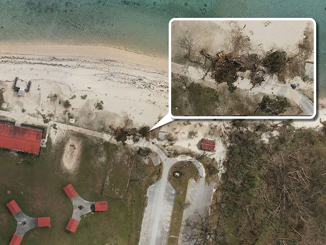
A portion of an orthomosaic map displaying the storm-related damage to Governor Joseph F. Flores Beach Park in Tumon, Guam is seen. (UNIVERSITY OF GUAM)
Fallen trees, broken power lines, and debris strewn across the island—these are just a few of the devastating sights captured via drone as part of a collaboration between the University of Guam and the National Weather Service Guam Forecast Office to map the aftermath of Typhoon Mawar.
Led by a team of remote pilots from various UOG programs, including the Drone Corps, NASA Guam Space Grant, NASA Guam Established Program to Stimulate Competitive Research, and the Pacific Islands Climate Adaptation Science Center, crew members assessed the damage from May 27 to June 8.
Disaster response through drones
With approximately 60 hours spent on drone flight, set-up, and processing, the mission amassed 11,758 photos that will be stitched together to produce high-precision orthomosaic maps, according to Jonelle Sayama, UOG environmental science graduate student and NASA Guam Space Grant fellow.
“The campaign leveraged advanced drone technology, including multiple DJI Matrice 300 drones and Zenmuse P1 sensors, that provided highly accurate survey data. With these state-of-the-art tools, researchers will be able to zoom in and see high-resolution visuals and actually pinpoint specific details, such as the species of trees that withstood typhoon-force winds and those that didn’t,” Sayama said.
Sayama was the campaign’s co-lead remote pilot alongside PI-CASC research assistant Dong Won Lee, who owns a drone service company. According to Lee, the project required a special waiver from the Federal Aviation Administration to map at higher altitudes. “The end product was an extremely high-resolution orthomosaic map that spans thousands of acres, with a ground sampling distance of 2.64cm. Having such a high-resolution GSD, which measures the distance between two consecutive pixel centers, enables scientists to delve deep into the smallest details, such as examining small cracks on the road.”
Meteorologists will be using the data to make detailed analyses regarding the typhoon’s winds, coastal inundation, and damage to the natural and built environment.
These assessments used to occur during “on-the-ground” site visits.
“Through the detailed aerial imagery, we now have the ability to view heavily damaged areas that would otherwise be too difficult or dangerous to access due to debris or fallen trees,” said Brandon Aydlett, NWS Guam’s Science and Operations Officer.
“This partnership showcases the power of collaboration in harnessing cutting-edge tools, providing data that will be instrumental in understanding the extent of the storm’s impact and potentially serving as a starting point for guiding future mitigation efforts.”
A new frontier for the UOG Drone Corps
The post-storm mapping campaign presents a new frontier in disaster response capabilities for the UOG Drone Corps which has primarily established itself in training remote pilots to assist in scientific research and construction projects.
“This is new territory for our program and members, pushing the boundaries of how our pilots can use the resources we offer to aid our community during times of crisis,” said Keanno Fausto, communications coordinator for NASA Guam Space Grant and coordinator for UOG Drone Corps.
Kaya Taitano, an Agricultural and Natural Resource Science major and a member of the UOG Drone Corps’ second cohort, said the mapping was challenging yet rewarding.
“We had a small, limited window of time to capture the data before clean-up began so we had to be as efficient as possible,” she stated. “I hope the information we gathered will give researchers an idea of where the storm surge was, and which infrastructure needs to be addressed for future decision-making processes.”
For more information about the data and study, contact Brandon Aydlett at william.aydlett@noaa.gov.
To learn more about the UOG Drone Corps program, visit www.bit.ly/dronecorps. (UOG)