Previous Story
NOAA to map Marianas seas in April
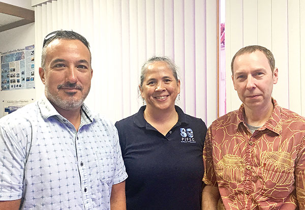
From left, program lead Garry Harsanyi, Science Operations Division director Noriko Shoji, and deputy director Dr. Evan Howell—scientists from the Pacific Island Fisheries Science Center who are working for the National Marine Fisheries Service at NOAA— are on the island to pre-facilitate the Mariana Islands ocean mapping that is set to begin in April 2020. (IVA MAURIN)
In April next year, a team of 60 scientists and crew from the National Oceanic and Atmospheric Administration will come to the Mariana Islands aboard the NOAA ship Rainier to map the seafloor of the Marianas and do coral reef research.
NOAA’s Office of Coast Survey and Office of Marine and Aviation Operations will be working together to perform the ocean surveys to measure the depths of water.
The data collected will be used to update nautical charts to make sure that coastal regions of the United States are safe for navigation and to develop hydrographic models. Hydrographic surveys support a variety of activities such as port and harbor maintenance, coastal zone management, and reef and fisheries research.
Detailed information on how deep the water is and the many characteristics of the seafloor would also be useful in determining fisheries habitat, understanding coral reef health as well as marine geologic processes.
For the 2020 operations, there will be two missions: coastal and habitat mapping, and the Mariana Archipelago Reef Assessment and Monitoring Program, or MARAMP.
Three scientists from the Pacific Island Fisheries Science Center—deputy director Dr. Evan Howell, Science Operations Division director Noriko Shoji, and program lead Garry Harsanyi—all working for the National Marine Fisheries Service in NOAA, are on island to pre-facilitate the mapping operations that would begin in April 2020.
“Ocean mapping is what gives you the depth of the water from the surface down,” Shoji said, “… and the additional piece is that, with the way we do mapping now, you can also identify what the bottom habitat might be, and what the bottom looks like.”
Shoji explained that this research is used for boat navigation, used by the fishermen to identify where they might fish, and is used by coastal managers to identify areas where to protect corals.
The mapping operations in the Marianas was last done in the ’70s and, with the change in technology and environment over the course of four decades, the CNMI could benefit greatly from the remapping of its ocean.
“Our second mission, MARAMP, is long-term monitoring of coral reefs, reef fish species, and oceanography in the area,” Howell said. “We go out with divers looking for coral reef fish, looking at the health of the coral reefs, the status of coral use, and then do oceanography, temperature, and look at [levels of] oxygen, nutrients, and carbon.”
The scientists will measure water temperature, salinity, carbonate chemistry, and other physical characteristics of the coral reef environment using oceanographic monitoring instruments.
Researchers will assess the potential early effects of ocean acidification on coral reef growth with calcification accretion units and bio-erosion monitoring units.
There are a number of ways for the community to be involved as scientists work on the mapping operations.
“When the ship comes out, and we have scientists give presentations, they can come and ask questions, and try to engage the scientists,” Shoji said. “[For] a number of our scientists, it will be the first time for them to be in the Marianas, so they will be interested in understanding what their work does and how it values the community.”
The NOAA ship Rainier is a 231-foot survey and research ship that will be operating 24 hours a day, from the south of Guam to Maug, between April and August 2020, using research equipment, deploying divers or transiting along specific survey lines. The ship operations will include two 28-foot hydrographic survey launches as well as two 24-foot dive platform vessels.
To learn more about NOAA’s hydrographic survey projects, visit https://nauticalcharts.noaa.gov or email coastsurveycommunications@noaa.gov.