Previous Story
More rain, strong winds expected until Sunday
Tropical disturbance, weak circulation to mess with weather
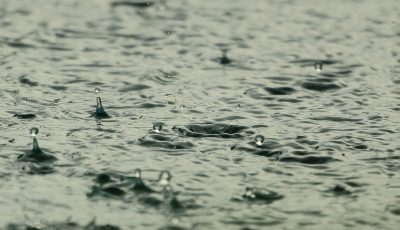
The Marianas region is expected to experience more showers and thunderstorms, particularly late tonight, Friday, through early Sunday morning, brought by a tropical disturbance and another weaker circulation.
According to the U.S. National Weather Service Guam, as of 4pm yesterday, a tropical disturbance was centered about 600 miles northeast of Guam and 500 miles northeast of Saipan.
NWS advised the public to be prepared for strong gusty winds and the possibility of flooding in flood-prone locations.
A monsoon surge associated with this disturbance is producing widespread cloudiness and scattered showers across the Marianas, said NWS meteorologist Marcus Landon Aydlett.
Aydlett said latest computer guidance keeps this disturbance north of Guam, Rota, Tinian, and Saipan the next few days as it interacts with another weaker circulation northwest of the Marianas.
“Further development with these disturbances will occur north of Saipan over the next few days and should not directly affect the Marianas,” Aydlett said.
However, he said, these disturbances will strengthen the monsoon flow over the islands with more showers and thunderstorms, particularly late tonight through early Sunday morning.
Aydlett said a strong ridge just south of the Marianas over Chuuk and Pohnpei will lift northward toward the Marianas Sunday.
“Exact timing of this will determine when showers and thunderstorms move out and drier weather builds in across the region,” he said.