

Previous Story
Just 34 villages in revised Saipan map
|
Posted on Jun 13 2022
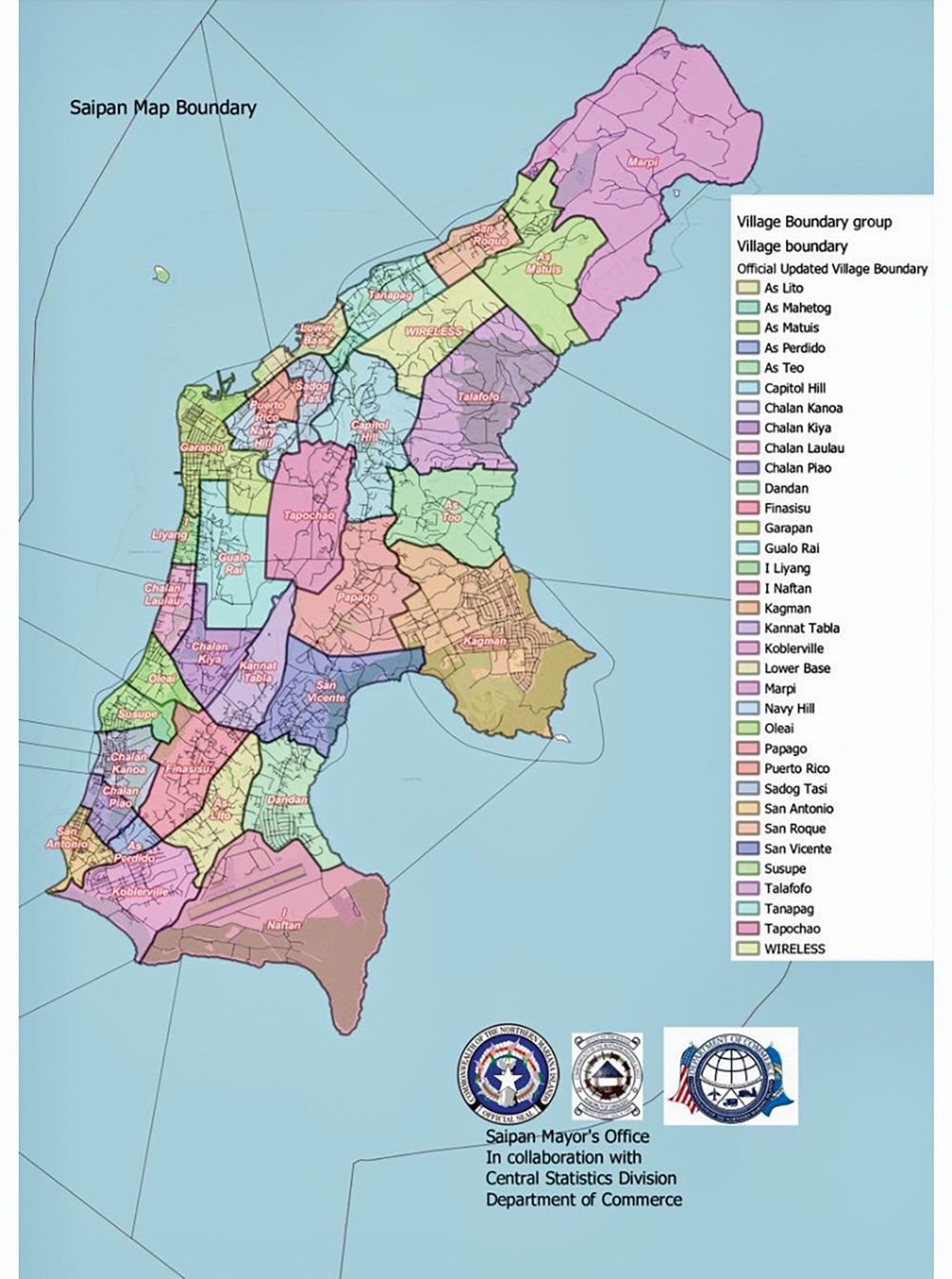
A revised map that seeks to set the boundaries of Saipan villages and ultimately bring down the number of villages from 73 to just 34 is now being considered and CNMI residents and former residents are being invited to submit comments, opposition, or suggestions between now and June 28.
Saipan Mayor David M. Apatang said in a news briefing last Thursday at the Saipan Mayor’s Office conference room that House Bill 22-82 seeks to create a new master map of the villages of Saipan.
He said the public is invited to attend the public hearing on H.B. 22-82 on Wednesday, June 28, at the CNMI Legislature. Written comments may be submitted directly to the Saipan Mayor’s Office from now until June 28.
“We’re inviting everyone in Saipan and even in the [United States] to submit comments. If they’re in agreement with this, we’d like to hear that. If they’re in opposition to this, we’d like to hear that,” said special assistant to the mayor Henry Hofschneider, who was also at the briefing.
He said the bill is called the Standard Village Delimitation and Name Master Map. It will identify villages by name and define the boundaries that separate one village from its neighbor. “Right now we don’t have a map that is adopted or approved by law or regulation that actually names all the villages and identifies the boundaries, so the bill would accomplish that,” Hofschneider said.
Right now the bill is at the committee level.
Although there is currently no standard master map of Saipan, most residents are familiar with the 73-village map from the Department of Commerce’s Central Statistic’s Division, which it uses for the census and other research purposes.
With the proposed map, sub-areas in villages will retain their names but will not be shown and those sub-areas will remain within boundaries as shown on the CSD census map.
The standard village delimitation identifies 34 village names: Marpi, As Matuis, San Roque, Tanapag, Wireless, Talofofo, Lower Base, As Mahetog, Sadog Tasi, Puerto Rico, Capitol Hill, As Teo, Kagman, Papago, Tapochao, Navy Hill, Garapan, Gualo Rai, I Liyan, Chalan Laulau, Oleai, Chalan Kiya, Kanat Tabla, San Vicente, Dandan, As Lito, Finasisu, Chalan Kanoa, Chalan Piao, As Perdido, San Antonio, Koblerville, I Naftan, and Susupe.
One reason for this master map is that it’s crucial to the work of the Saipan Mayor’s Office Saipan Street Naming and Numbering Division, which is in charge of assigning establishments and residences their own building numbers. The street that a building is close to, its assigned number, and the village where the building is located are all part of a street address.
Other advantages cited for the revised map is that identifying a location by village name and street address should reduce the response time for police, fire, or medical services in saving a person’s life and door-to-door mail and package delivery.
Additionally, it may enhance property location for purposes of verification of title ownership and delivery of aid and assistance post-natural disasters.
It was assured that the proposed master map will haves no effect on the CNMI Saipan election precinct map. “Until the Commonwealth Election Commission re-draws the election precincts delineation, the village delimitation shown on the master map shall not affect the election precinct boundaries based on the last apportionment,” part of the bill states.
“We’re pushing for this to be passed so we can finish up our home numbering project. …Right now there’s no official boundary line or any official map for the island of Saipan so this is our mission to make sure that we have that, so people won’t be encroaching into the other villages and say I live in San Vicente and yet you’re in Dandan,” said Apatang.


