Previous Story
WHERE’S THE BEACH?
DCRM Area of Particular Concern: Shorelines
Everyone enjoys a day out at the beach. It is always a pleasure to walk along a clean corridor of white sandy beach. Hedged between a row of native trees and grassy vegetation on one side and a vast ocean on the other, it forms a natural harbor. The connection between the land and the sea is a valuable and sacred place. Shorelines are far more than just beaches, places to build sand castles, or go shell hunting. It is home to diverse marine and terrestrial wild plants and animals. It is a living ecosystem that shapes the landscape that we know today as beaches, shorelines, or coastal areas. Perhaps just as important, a place where we nurture ourselves, our family, our community, and our heritage. We view beaches or shorelines as a place for family gatherings, festival events, near-shore fishing, a place where important rituals or traditional ceremonies are performed, or the beginning and the end of a long and tiring oceanic navigation. To the natural environment, it is simply, home.
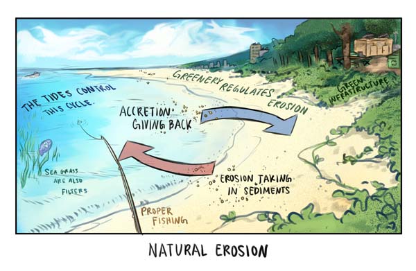
Unfortunately, today, our beaches and shoreline areas are at risk of degradation due to bad practices of human-induced activities, such as unpermitted and poorly designed developments, poorly regulated recreational activities, and ongoing bad practices of apathetic beach users. Beach erosion is also another negative effect of shoreline degradation. However, erosion does occur naturally with waves and currents affected by climate change.
Community-wise, we can do our part in ensuring healthier shorelines by preventing or avoiding the uprooting or trampling of shoreline vegetation, proper disposal of debris and trash, and increase support for better regulations for coastal developments such as minimizing negative effects of a construction project, teaching our children best practices while at the beach, replanting of vegetation and trees along the shorelines, volunteer for a beach cleanup, or bringing your trash home after a picnic at the beach.
The current health status of our shorelines can be viewed on DCRM’s website under the 2018 Saipan Shoreline Access and Shoreline Enhancement Assessment (SASEA). The beaches are rated from high, medium and low risk based on the balanced scale of human interaction and shoreline health. An example of this assessment process: if the vegetation to a shoreline has been degraded because of human involvement (construction or the removing of plants), then it becomes necessary to reduce our interaction. This can be seen at the Kilili Beach (former Civic Center), in which constant vehicular traffic compacts the soil and eventually is unable to support its vegetation (Issue G, SASEA, 2018). The only time it is necessary to remove beach vegetation is when it becomes overgrown and hinders public access. Vegetation removal must adhere to certain criteria to ensure shoreline stability. An example of regulated vegetation removal is the Quartermaster Area (Red Beach) where vegetative growth spread near the water line (Issue F, SASEA, 2018).
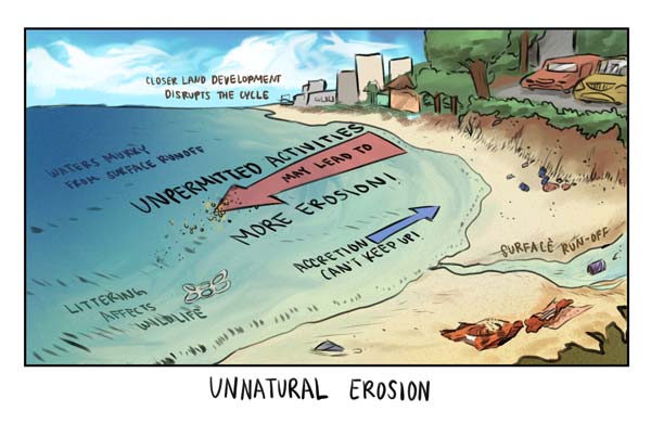
Shorelines within “high risk” tiers usually have high levels of human activity and erosion with little to no plant life. Therefore, understanding of the processes to our environment is another step for our communities to guarantee a healthier island. One critical process of our island is naturally occurring erosion. Erosion only becomes detrimental to human built environments when eroding beaches threaten infrastructure. Natural erosion is when sediment is removed from our beaches in a slow and steady pace, with accretion (the gaining of sand) countering that. It’s this cycle that we must not disrupt to the best of our abilities. A few ways we can maintain stable shorelines is by not harvesting coastal vegetation, creating permeable parking lots (which decrease surface water runoff), being mindful of where we park our vehicles, and picking up litter whenever you travel to our beautiful white sand beaches. Keeping our shorelines happy and healthy boils down to responsible use. Together, we can work towards better managing our coastal resources.
DCRM’s mission is to protect and enhance the CNMI’s coastal resources for residents and visitors through effective and adaptive resource management, interagency collaboration, and stakeholder engagement, in a manner that builds and sustains community resilience and well-being.
If you are proposing a project or activity within the Shoreline APC, please apply for a coastal permit at the BECQ-DCRM, Permitting Section, Gualo Rai Center, Suite 303, Middle Road, Lower Gulao Rai, or call Permitting Section at 664-8300 for more information.
WORDS TO KNOW:
Shorelines—the geographic area of particular concern consisting of the area between the hightide line or edge of a shoreline 150 feet inland on the islands of the Northern Mariana Islands chain.
* * *
Cerijean F. Mangubat is a student at the Northern Marianas College and currently serves as a summer intern with the Division of Coastal Resources Management. This article is the second of a short series that discusses the significance of DCRM’s areas of particular concern (APCs) and why these resources are subject to special management standards.