Previous Story
Initial survey of Marianas coral reefs now finished
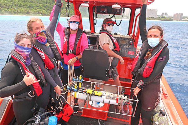
The ocean and climate change team prepare a suite of instruments to carefully lower to the seafloor to record environmental information. (NOAA Fisheries)
Coral reef scientists aboard the NOAA Ship Rainier recently completed their first 24-day survey of the reefs in the Marianas archipelago.
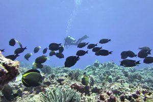
According to a release from the Ecosystem Sciences Division of the Pacific Islands Fisheries Science Center on updates about the Rainier Marianas cruise, one team conducted 108 surveys around the islands of Guam, Saipan, Tinian, Aguiguan, and Rota. They assessed their reef fish populations by counting the number of each species of fish and estimating their sizes. The team counted all kinds of fish, from stingrays to anemonefish.
A scientist conducts a reef fish survey at Aguiguan Island. (NOAA FISHERIES/MIA LAMIRAND)
Another coral reef team was busy measuring ocean conditions with an array of instruments. They collected water samples at 94 sites, and retrieved and deployed more than 130 instruments. These instruments measured water temperature, depth, currents, pH, dissolved oxygen, and light.
The scientists also photographed the seafloor to create three-dimensional models of the reefs, which will show what is growing on them. At sites that are re-visited over time, they will see how much coral has grown or if coral colonies have died.
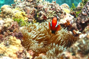
A curious anemonefish looks at a diver during a fish survey on Tinian. (NOAA FISHERIES/MATT CHAUVIN)
Another team mapped the shallow areas using two small boats while the Rainier collected data in the deeper areas. These mapping surveys include bathymetry (water depth) and backscatter (bottom type) data. Scientists combine them to create detailed three-dimensional maps of the seafloor and its different habitats. These maps will update nautical charts and support marine resource management in the region. The Rainier charted areas that have not been surveyed in more than 80 years!
This is just the beginning of the Rainier’s mission, which will run through August. For now, these scientists have traveled back to Honolulu and a new group of coral researchers have joined the ship.
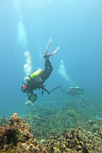
Divers swim in concentric circles collecting images of the reef that they will stitch together later to form a three-dimensional model. (NOAA FISHERIES/K. URQUHART)
The Rainier Integrates Charting, Hydrography, and Reef Demographics mission aboard the NOAA ship Rainier kicked off its first leg in March. In this mission, scientists with different backgrounds share the goals of measuring water depths, mapping the seafloor, and gathering information on coral reef habitats. The data from this mission will support efforts in the region including the National Coral Reef Monitoring Program’s long-term coral reef monitoring and nautical charts.
Be sure to follow the progress on their coral and mapping story maps and the Rainier’s Facebook page! (PR)