Previous Story
Weather forecaster shares tips in event of typhoon
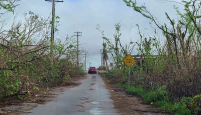
National Oceanic and Atmospheric Administration forecaster Brandon Aydlett shared some tips on how to prepare for an imminent typhoon during SOU’ Fest 2016, the first anniversary commemoration of Typhoon Soudelor held last Aug. 6 at the Marianas Business Plaza parking lot.
“Some of the things you can do to prepare is to fill your cars with fuel; obtain batteries, flashlights and battery operated radios; get enough fuel for lamps, stoves, and generators, and fill containers with several days [worth] of water,” he said.
Aside from providing tips on how to be prepared for an incoming typhoon, Aydlett’s group of NOAA forecasters also handed out brochures that listed the different types of typhoons.
Aydlett said Typhoon Soudelor was a category 4 typhoon.
According to the brochures given out by Aydlett and company, there are two different types of tropical storms—tropical storm category A and category B. Tropical storm category A is described as having waves inside bays that can reach 2 to 3 feet, while tropical storm category B is described as having waves inside bays that can reach 3 to 5 feet.
After tropical storm category A and B, the next typhoon intensity is typhoon category 1. This type of typhoon is like having waves inside bays that can reach 5 to 7 feet. The next one is typhoon category 2. This is described as having waves inside bays that can reach 7 to 10 feet.
Typhoon category 3 is described as waves inside bays that can reach 10 to 5 feet. Typhoon category 4, which Typhoon Soudelor was, is described as having waves inside bays that can reach 15 to 25 feet.
The final category is typhoon category 5. This is described as having waves inside bays that can reach 25 to 35 feet.